Where did the idea for the Green Loop come from?
The idea for the Green Loop emerged from community conversations during the early days of the Central City 2035 Plan regarding the future of downtown Portland. As originally conceived, the Green Loop was a way to improve health outcomes, add much needed open space on the east side and create a space where more people would feel comfortable, walking, jogging, rolling or riding — a way to help achieve ambitious active transportation goals set for 2035.
Are there projects like the Green Loop in other cities?
There are many projects like the Green Loop in other cities around the US — in different phases of development: planning, design construction or use by the community. The Green Loop’s main precedents are the Indianapolis Cultural Trail (Indianapolis, IN) the 5280 Trail (Denver, CO) and the Underline (Miami, FL). It is also inspired by larger, or elevated linear park projects, like the Beltline (Atlanta, GA), the Highline (NYC, NY) and the 606 (Chicago, IL). Numerous other precedent projects similar to the Green Loop exist in other cities and countries around the world.
What are the primary goals of the project?
There have been three key goals that have remained constant over the Green Loop’s evolution. They are 1) Economic Development — enabling new and innovative spaces for micro-businesses in the heart of downtown Portland; 2) Accessibility and Inclusion — expanding safe, comfortable and unhurried access for all Portlanders to regional and cultural attractions and destinations; and 3) Placemaking — creating a whole new way, and series of linked public spaces, to experience Portland’s Central City…like “Sunday Parkways” everyday.
Does the Green Loop exist? Is it being built?
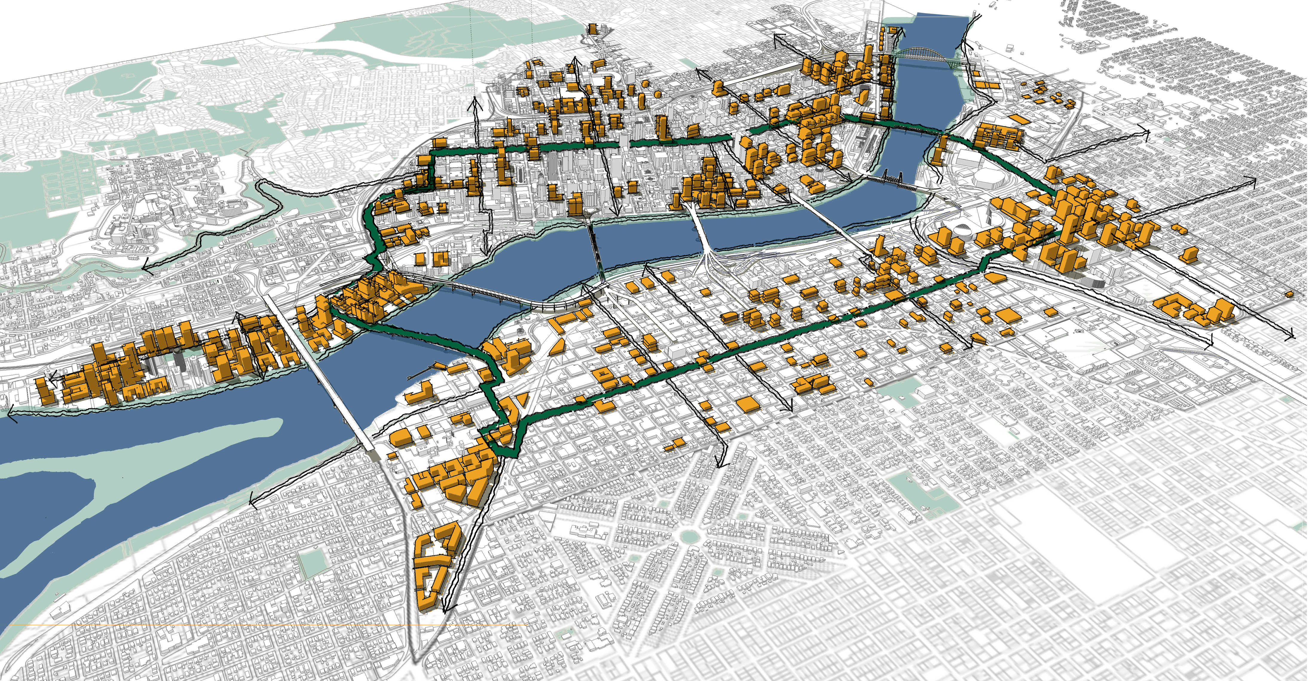
A few pieces of the Green Loop exist today — the Broadway and Tilikum Bridges, as well as the trail segment of SW Moody between Harbor Drive and SW Porter in South Waterfront. Other pieces of the alignment are getting built right now — most notably the Earl Blumenauer Bridge across the Interstate 84 Freeway between Lloyd and Central Eastside. Other major segments are being planned and designed, including the segment through the former US Post Office site and the alignment along the South Park Blocks.
How much will the Green Loop cost? Where will the funding come from?
Projected costs and financing sources for the entire Green Loop haven’t been comprehensively determined yet. Similar projects in other cities have had capital construction costs of $8 – 10M per linear mile. It is likely that funding for the project will come from a variety of sources, including grants, local improvement districts, tax increment financing, public funds, and private philanthropy. Since the project’s specific funding strategy has not been determined yet, it is possible that the Green Loop could test a “value capture” model where some amount of funds that are generated by the project could be used to implement similar projects in other parts of the city.
How will the project be built?
The Green Loop will get built in a few different ways. One is through major public infrastructure projects, like the Earl Blumenauer Bridge or the “Hill Park” near RiverPlace. Another is through capital improvement projects, where streets get rebuilt and become new spaces for people. A third way the project will be built is through development regulations and frontage improvements that happen with new buildings.
Will the Green Loop cause gentrification and displacement?
Gentrification is always a worry — and can be an unfortunate side effect — with any public infrastructure project in any part of the city. As the financing for the green loop hasn’t been fully determined yet, there may be opportunities for “value capture” financing models that could help reserve funds to help address gentrification pressures (where they may emerge) with the project’s implementation. While we 100% agree that the forces of gentrification need to be considered early and addressed to the extent feasible, we also don’t want to unnecessarily stifle creativity and innovation in the design of the city’s public spaces — necessary to address long term resiliency in the era of climate change for thousands of residents, workers and visitors.
Why is it in the Central City? Doesn’t the Central City have enough already?
Portland’s Central City is expected to take a third of the city’s growth over the next twenty years — which is a lot: some 37,000 new households and around 50,000 new jobs. It will need new connected open spaces like the Green Loop to support these new residents, workers and visitors. In addition, Portland’s Central City continues to serve the city’s most vulnerable residents: it possesses the densest concentration of social service facilities in the State of Oregon and offers the largest amount of state-regulated affordable housing in the region. It will need investments in new infrastructure that can better serve these communities with inclusive spaces that feel welcoming to all.
How will the green loop contribute to livability/resiliency in Portland?
The green loop will create a multi-functional, comfortable, and connected public space that will appeal to Portlanders of all ages, abilities and backgrounds. It will offer affordable, healthy access to cultural attractions, currently located in the Central City but a part of everyone’s city. It is a critical piece of Portland’s commitments to “growing up, not out,” increasing the livability of Oregon’s densest location and helping to preserve surrounding agricultural and environmental lands. Because of its central location and connections to newer structures (like bridges) it could also provide an easily identifiable lifeline in the event of a seismic or other natural catastrophic event — offering spaces for people to gather, receive assistance and/or get information disseminated.
I have an idea for the Green Loop, how can I send it to you?
We would love to see it! Please send it to info@pdxgreenloop.org.